


Javols-LaBessiere

raymondfn
User
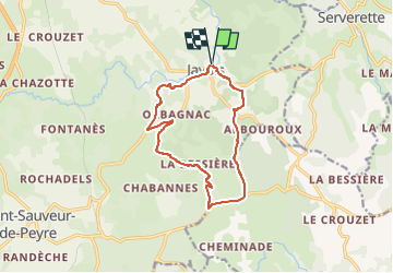

Length
12.4 km

Max alt
1091 m

Uphill gradient
256 m
Km-Effort
15.8 km

Min alt
975 m

Downhill gradient
255 m
Boucle
Yes
Creation date :
2024-04-26 15:26:01.471
Updated on :
2024-05-09 16:02:58.912
3h35
Difficulty : Difficult

FREE GPS app for hiking
 SityTrail
IGN / Geographical institutes
SityTrail Plus
The world is yours!
About
Trail Walking of 12.4 km to be discovered at Occitania, Lozère, Peyre en Aubrac. This trail is proposed by raymondfn.
Positioning
Country:
France
Region :
Occitania
Department/Province :
Lozère
Municipality :
Peyre en Aubrac
Location:
Unknown
Start:(Dec)
Start:(UTM)
527206 ; 4948995 (31T) N.
Comments